"At night it is known for the electronic gates to be left open, allowing the possibility of a free ride on the train (this is not condoned), as well as allowing local youngsters to congregate on the platform and engage in freestyle rapping battles."
(from http://en.allexperts.com/e/f/fe/feltham_railway_station.htm)
Tuesday, 10 November 2009
Monday, 9 November 2009
Old Photos - 1910


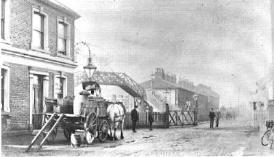
PHOTO 1. Taken from Bedfont Lane, looking towards Bedfont. The 'Railway Tavern' pub on the left was demolished with the construction of the new Feltham Development. The building in the background are now the site of a car park and a parade of shops.
PHOTO 2. The same view today, the pub and the row of houses have been demolished, the footbridge has been replaced by a
concrete one and the level crossing gates have been replaced by electronic ones
PHOTO 3. Taken from the footbridge looking London-bound. The building in the right of the picture is now the site of Blockbusters and McDonalds.
PHOTO 4. This is from the same view as the picture above. The signal box has been demolished and the sidings have been removed in order for the platform to be extended. The level crossing gates have been replaced and the house has been demolished, and Blockbuster is now situated there. You can also now see the new station building in the left of this picture
Sunday, 8 November 2009
A bit of History....
Feltham was a very small, remote, agricultural village, completely surrounded by Hounslow Heath. The village was centred around St Dunstan's Church and St Dunstan's Road. It was not until 1848, with the construction of the railway line through Feltham that the centre moved to the new High Street and the area around Feltham Green and Feltham Pond
By the 1880s the population was over 3000, with most people living in the area around Feltham Station.
(information from 'Feltham, Hanworth and Bedfont - A Pictorial History' by Andrea Cameron 2002)
Tuesday, 3 November 2009
Maps


As you zoom in on Feltham the townscape really starts to show. With the first two images it really is alot to do with geography, that's why i labelled the key points near to Feltham. Even in the second map you can see the town starting to come into view but the road layouts shown in map 3 show that the town is really not that big and that it is all quite compact in some areas, apart from the various green areas.
Post 3

This is a South West Trains network map of the area. It shows Feltham (highlighted in the circle) and London Waterloo. The close proximity to London was one of the main reasons why the station became popular from the end of the 19th Century and commuter volume is still increasing today as you can see below:
Yearly Usage
2004 / 2005 1.864million
2005 / 2006 1.967million
2006 / 2007 3.014million
2007 / 2008 3.374million
Monday, 2 November 2009
Post 2
 This picture is from the road bridge looking eastwards towards Ashford. The building on the left of the picture used to house a footbridge to the platform on the right (London-bound). This is the platform view of the building mentioned in my post above. The footbridge shown in the distance was constructed when this building was closed
Post 1
 This picture shows the front of the station from the far right had side. The area with the red shutters was an area used formerly to access the London-bound platform but is now not in use.
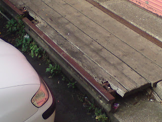
 This picture shows use of old railway track as a front for the parking space and sleepers used for the step beyond (the picture below is from the bottom right hand corner of the picture left)
This shows use of old materials (however dilapidated) in the construction of local buildings.
Subscribe to:
Comments (Atom)